GIS For Good

A worldwide initiative by RomoGIS using Geographic Information Systems as a powerful tool for social change and sustained community development.

Technology for Social Change

We believe in the transformative potential of GIS to create more sustainable and equitable communities worldwide.

Empowering Communities

RomoGIS was founded to empower people with the technology, tools and tactics to improve their local communities. We turn local insight into action through GIS, drones, and community-driven data.

Click to see our impact
Community

Community Impact

Power limits access to data because data is powerful. That is why we teach youth to claim their power, build that access, and tell their stories.

13+
Cities
50+
Partners
100%
Local Focus

Developing Leaders

Our GIS For Good initiative develops leaders across the industry who are committed to making an impact on social issues. We train entrepreneurs, advocates, and researchers to leverage GIS for positive impact.

Click to see our impact
Teaching

Leadership Development

Building pathways for youth to see themselves as leaders who can transform their communities through technology.

2K+
Trained
95%
Complete
8
States

Creating Change

We develop innovative geospatial platforms that enhance community development, safety, and quality of life. These platforms provide precise, actionable data that informs strategic planning and community organizing.

Click to see our impact
Drone Training

Real-World Solutions

When the tornado hit North St. Louis, we turned their headquarters into a neighborhood distribution hub within hours. That's GIS For Good in action.

10+
Apps Built
1M+
Data Points
500K
Reached
13+
Cities Reached
2,000+
Students Trained
8
States Active
50+
Partners

GIS For Good Services

Comprehensive programs designed to create lasting community impact through geospatial technology.

🎓

K-12 STEM Programs

Hands-on learning in drone technology, GIS, and emerging technologies to empower the next generation of STEM leaders.

View Case Study
📊

Strategy & Capacity Building

We collaborate with community organizations and local governments to provide strategic technical advisement and assistance.

View Case Study
🗺️

Tech Solutions for Good

GIS-based applications addressing community issues and providing opportunities to make local community impact.

View Case Study
🎯

Workshops for Social Impact

Customized workshops covering mapping of social vulnerabilities, environmental hazards, and socio-economic factors.

View Case Study
📚

GIS Courses

Training in ArcGIS Online, QGIS, Google My Maps, and Survey123 to equip everyone with mapping skills.

View Case Study
🚁

Drone & UAV Training

Professional drone flight certifications and aerial mapping training for students and professionals.

View Case Study

About RomoGIS

🗺️

Founded for Community Impact

RomoGIS is a dynamic data, design and research collaborative dedicated to enhancing the public good through targeted advocacy, research and direct community engagement.

Founder Frank Romo's background as an urban planner, community organizer, and educator has allowed him to develop curriculum and products specifically tailored towards community empowerment and social justice.

Our past clients include non-profit organizations in Detroit, Michigan, research organizations in Los Angeles, California and international non-governmental organizations in India and France. In each project, we work to empower people with the technical and organizational skills to advocate for greater equity.

Ready to Make an Impact?

Join communities across America using GIS technology to create positive change in their neighborhoods.

Join the Movement

Help us empower communities through GIS technology. Share your information and let us know how you'd like to get involved with the GIS For Good Movement.

Get Involved Today

Whether you're a student, educator, professional, or community advocate, there's a place for you in the GIS For Good Movement. Fill out the form below and we'll connect with you.

🎉 Thank you for joining the GIS For Good Movement! We'll be in touch soon.

GIS For Good Services

Empowering communities with cutting-edge geospatial technology, training, and solutions that drive meaningful social change.

The GIS For Good Initiative

GIS For Good is an initiative by RomoGIS to create change using technology. We train entrepreneurs, advocates, and researchers to leverage GIS for positive impact, equipping them with the skills and tools needed to address critical social challenges.

By developing innovative geospatial platforms, we enhance community development, safety, and quality of life. These platforms provide precise, actionable data that informs strategic planning, resource allocation, and community organizing.

🎯 Community Focused 📊 Data-Driven 🌍 Social Impact 🤝 Collaborative
13+
Cities
2K+
Trained
50+
Partners
8
States

Our Core Services

Comprehensive programs designed to create lasting community impact through geospatial technology and education.

K-12 STEM Programs

Our K-12 programming provides hands-on learning in drone, GIS, and other technologies to empower the next generation of STEM leaders.

See the impact
FDA Students

Detroit GIS Pathways

Frederick Douglass Academy
"Students from FDA were invited to present at the 2025 Association of American Geographers Conference at Huntington Place!"
Part 107 Prep Drone Bootcamp Mock Interviews Paid Internships

Strategy & Capacity Building

We collaborate with community organizations and local governments to provide strategic technical advisement and assistance.

See the impact
Tech Support

LOVEtheLOU Partnership

Tornado Recovery Response
"We trained youth leaders in digital skills to help catalog and visualize data in real-time. In the first 72 hours, over 500 packages were delivered."
Data Systems Staff Training Dashboard Dev Long-term Plans

Tech Solutions for Good

Our GIS-based applications address community issues and provide users opportunities to make local community impact.

See the impact
Fire Dashboard

LA Wildfire Response

Eaton & Palisades Fires
"Intern Christian Robles helped build damage assessment applications to support fire response, then presented our solutions at the 2025 Esri User Conference."
Damage Assessment Real-time Data Community Access Recovery Support

Our GIS Courses

Our courses provide you with technological skills in ArcGIS Online, QGIS, Google My Maps, and Survey123. We focus on imparting core principles of GIS mapping, ensuring students develop both theoretical understanding and practical expertise.

🗺️

Intro to ArcGIS Online

Gain comprehensive understanding of online mapping using the Esri platform. Learn to leverage powerful capabilities for mapping, data analysis, and visualization.

See curriculum
🗺️

ArcGIS Online

What You'll Learn:

  • Web map creation & sharing
  • Layer management & styling
  • Spatial analysis tools
  • Dashboard building
📍

Intro to Google My Maps

Master the Google My Maps interface, create personalized maps, integrate external data, and design custom web maps to meet diverse needs.

See curriculum
📍

Google My Maps

What You'll Learn:

  • Custom map creation
  • Data import & integration
  • Marker customization
  • Sharing & collaboration
📋

Intro to Survey123

Learn to format online applications and surveys with Survey123. Translate survey results into dynamic maps that visualize and communicate data effectively.

See curriculum
📋

Survey123

What You'll Learn:

  • Form design & logic
  • Mobile data collection
  • Results visualization
  • Map integration

GIS for Social Impact Workshops

RomoGIS offers workshops that focus on the use of GIS for social impact and change. Our team's experience in community advocacy helps us create customized workshops and applications that support and empower community stakeholders.

Our workshops emphasize active participation, where community members engage directly with GIS tools and technologies through practical exercises.

📊
Mapping Social Vulnerabilities
🌿
Environmental Hazard Analysis
💹
Socio-Economic Factor Mapping
🏘️
Community Development Planning
GIS Workshop

Ready to Get Started?

Partner with us to bring GIS technology and training to your community, organization, or school.

Solutions For Good

We develop tailored geospatial applications that solve specific problems within communities. Our solutions empower communities by equipping them with the knowledge and skills needed to utilize geospatial technology for real change.

🔥

Emergency Management

Real-time disaster response and recovery mapping solutions

Emergency

2025 Palisades Fire Damage Evaluation

Dashboard highlighting the structural impact of the Palisades Wildfire. Visualizes critical parcel-level and building-level data statistics showing the large scale impact.

Emergency

2025 Eaton Fire Damage Evaluation

Dashboard highlighting the structural impact of the Eaton Wildfire. Exemplifies how GIS can be used for environmental monitoring, emergency response and long-term recovery.

Emergency

Mapping the Damage of the Eaton Fire

Visual representation of the damage assessment reports from the 2025 Eaton Wildfire. Uses GIS as a tool to illustrate the tragedy and stand in solidarity with Angelinos.

Emergency

Mapping the Damage of the Palisades Fire

Damage assessments reports and images from the 2025 Palisades Wildfire. Allows users to learn more about their surroundings and visualize wildfire damage.

🛡️

Violence Reduction & Community Safety

Data-driven solutions for safer communities

Safety

Mapping Firearm Suicides in California

Created with Hope and Heal Fund, this dashboard maps reported firearm homicides and suicides in California from 2016-2022, shedding light on the impact of firearm deaths.

Safety

Mapping Gun Violence in California

In collaboration with Hope and Heal Fund, this accessible application maps reported firearm homicides from 2014-2022 to strengthen advocacy efforts preventing firearm violence.

💚

Public Health

Mapping health equity and environmental factors

Health

Health Equity for Black Communities

Partnered with Ceres Research to map health access for black residents in Contra Costa County. Used to identify ideal locations for public health interventions like mobile healthcare units.

Health

MI-Environment Heat Vulnerability

Collaboration with University of Michigan School of Public Health investigating geospatial patterns of heat stress vulnerability across Michigan to inform interventions for at-risk communities.

Have a Community Challenge?

Let's build a custom geospatial solution that addresses your community's unique needs and creates lasting impact.

📖 Case Study & Impact
🎓

K-12 STEM Programs

Empowering the next generation

Description goes here...

✨ What You'll Get

GIS For Good Tour 2025

The GIS For Good Movement is transforming communities across America through technology and mapping. Visit www.gisforgood.com and www.romogis.com to learn more.

Our core mission: training over 1,000 people in 2025 and creating applications that support public safety, health, wellness, and the public good. Join us in empowering the next generation of GIS leaders and changemakers.

Join The Movement

Empowering Communities Through Technology

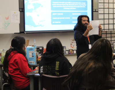
The GIS For Good Tour 2025 brings cutting-edge geospatial technology and drone training to underserved communities across America.

Our mission: equip the next generation with the skills to map what matters, tell their stories, and create lasting change in their neighborhoods.

Scroll to explore

Los Angeles, California

Community Organizing & Social Justice

Los Angeles GIS For Good

Frank Romo's passion for community activism began in Los Angeles, where he organized food and labor justice campaigns before founding RomoGIS.

Working on issues ranging from gun violence mapping to community safety, RomoGIS continues to partner with LA organizations to address social inequities through data-driven advocacy.

Impact: Training 30+ nonprofit organizations on mapping gun violence and using data to advocate for better policies.

Monterey & Salinas, California

Rural Community Mapping Workshops

Community Mapping

RomoGIS conducts 1-2 day workshops in rural California communities, empowering students to map what they see, identify challenges, and propose solutions.

In Monterey and Salinas, students identified areas where they felt unsafe due to drug and firearm-related activities. Their mapping revealed that most safe spaces required money, leading to a successful grant application for an after-school lounge.

Impact: Student-driven mapping leading to tangible community resources and safe spaces for youth.

CSUN Northridge, California

Inspiring Student Leaders for Local Change

CSUN Presentation

At California State University, Northridge, RomoGIS shares the GIS For Good Movement with student leaders, inspiring them to use mapping technology for local community change.

Through partnerships with Dr. Sheila Lakshmi Steinberg, the Geography Department, and the Institute of Sustainability, we're training the next generation of changemakers in Southern California.

Impact: Spreading GIS For Good principles to inspire student action and community-driven technology projects.
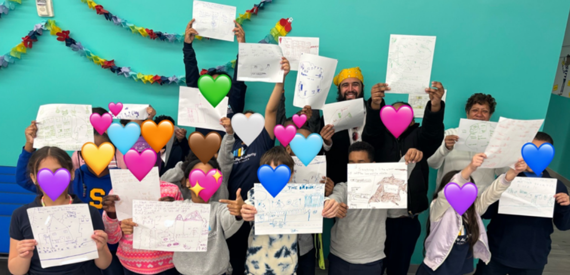
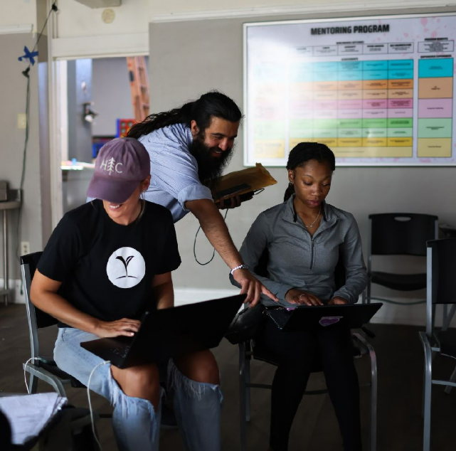
The Bronx, New York

Community Safety & Youth Leadership

Bronx GIS For Good

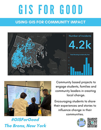
In partnership with the Angellyh Yambo Foundation and La Central YMCA, we're training Bronx youth to use GIS and AI tools to reimagine public safety.

Students map their neighborhoods, identify safety concerns, and present data-driven solutions to community leaders—including Bronx District Attorney Darcel Clark.

Impact: Youth-designed community centers, safe routes to school, and student voices influencing policy change.
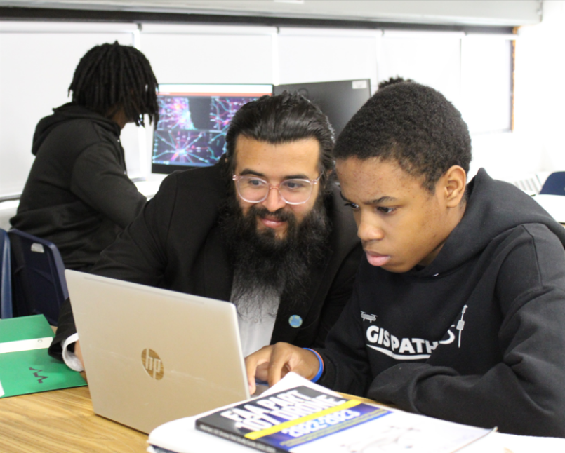
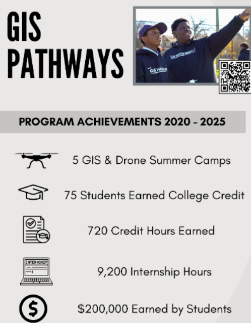
→ Read the full story

Detroit, Michigan

Workforce Development & STEM Innovation

Detroit GIS For Good

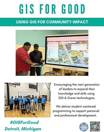
The GIS Pathways Program at Frederick Douglass Academy provides high school students with college-level GIS training and professional development opportunities.

From drone flight certifications to paid internships with industry partners like OHM Advisors and Esri, students gain hands-on experience while addressing local challenges like food access and environmental justice.

Impact: Students leading drone camps, creating community maps, and launching careers in geospatial technology. Student interns presented to 250+ professionals at GIS-Pro 2023.

→ Explore the program

Ann Arbor, Michigan

GIS for Architecture & Urban Planning

University of Michigan Workshop

At the Taubman College of Architecture + Urban Planning, University of Michigan, RomoGIS leads graduate-level workshops teaching architects and urban designers how to leverage GIS for community impact.

Through the TV LAB collaboration, students learn how RomoGIS uses GIS, drone technology, and urban planning to support local community development through projects in St. Louis, Detroit, and New York.

Impact: Equipping future architects and urbanists with tools to develop more livable, equitable communities.

Nashville, Tennessee

Mapping for Community Change

Nashville GIS For Good

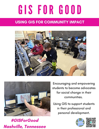
At Central Magnet School in Murfreesboro, 11th and 12th graders learn to leverage GIS, ArcPro, and StoryMaps to tackle real-world challenges in housing access, food deserts, and public safety.

Student projects were showcased at the Tennessee Geographic Information Council's 2025 Conference, where they presented to over 300 GIS professionals.

Impact: Student interns supporting disaster recovery efforts in St. Louis and building statewide innovation pipelines. Students presented as keynote speakers alongside industry professionals.

→ Learn more about the program

Nashville, Tennessee

Tennessee State University - Community Mapping

TSU Students with Drones

Through collaboration with Tennessee State University leaders including David Padgett and Reginald Archer, Ph.D., GISP, RomoGIS brings hands-on community mapping and drone training to students in North Nashville.

Students explore how spatial data, GPS, and mapping tools document neighborhood assets, identify local challenges, and tell meaningful stories about the places they live.

Impact: Core GIS skills and hands-on drone flight training for TSU students, empowering community storytelling through technology.

Knoxville, Tennessee

Advanced UAV Operations at UT Knoxville

Students in Knoxville flying drones

Working with Michael Camponovo and the University of Tennessee, Knoxville Geography Department, RomoGIS has led workshops and presentations for three consecutive years.

Students learn about GIS For Good, entrepreneurship, workforce development, and the geospatial professional world, while exploring advanced UAV operations with Tim Kane and Matthew Trent.

Impact: Multi-grade engagement from K-12 to university level, showcasing flexible educational approaches and building Tennessee's GIS leadership pipeline.
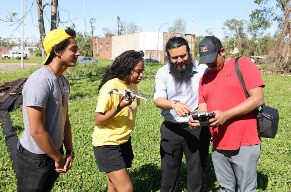
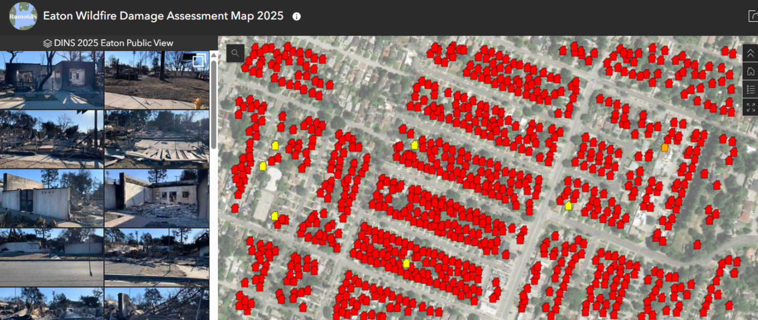
St. Louis, Missouri

Emergency Management & Disaster Recovery

St. Louis GIS For Good

After a devastating tornado struck North St. Louis, we partnered with LOVE the LOU to train over 100 residents in drone technology and digital mapping for disaster assessment.

High school students led younger peers through mapping activities while elders tried drone flight for the first time—creating powerful intergenerational learning experiences.

Impact: Community-led damage assessments, efficient resource allocation, and workforce development for rebuilding efforts. Local leaders gained professional skills for future employment opportunities.

→ See the impact story

Minneapolis/St. Paul, Minnesota

Government GIS & Infrastructure Planning

Frank speaking in Minneapolis

In Minnesota, RomoGIS connects with state and local government leaders and nonprofit organizations, sharing how communities nationwide use GIS to drive meaningful change.

Working with partners like Raintry Salk, Molly McDonald, and Sarah Brown in Bloomington and St. Paul, RomoGIS supports local government agencies in using spatial analysis to align bond and infrastructure investments with real community needs.

Impact: GIS-driven infrastructure planning improving air quality, workforce development, and community investment strategies.

Madison, Wisconsin

Leveraging GIS for Social Impact

Keynote at Wisconsin

At the Wisconsin Land Information Association, RomoGIS delivered the keynote workshop "Leveraging GIS for Social Impact," presenting the community change model that brings together GIS professionals, educators, students, and community leaders.

The workshop showcased partnerships and impact across Detroit, New York, California, and Tennessee, demonstrating how organizing, research, and community action create lasting change.

Impact: Inspiring Wisconsin GIS professionals to utilize technology for personal and professional development, strengthening the workforce and industry.

Albuquerque, New Mexico

GIS For Good Workshops & AAG Partnership

Frank speaking at New Mexico event

RomoGIS's first stop in New Mexico brought multiple workshops teaching geographers how to use GIS For Good to support community safety, disaster recovery, and positive social impact.

Workshops demonstrated tools like Google My Maps, Survey123, and ArcGIS Online to create community impact and tech empowerment. A highlight was the panel with American Association of Geographers President William Moseley, discussing how RomoGIS builds pathways to Geography in K-12 and undergraduate programs nationwide.

Impact: Expanding GIS For Good reach to New Mexico's geography community, fostering workforce pipelines to the geospatial industry.

Join the Movement

The GIS For Good Movement is transforming communities across America—one map, one student, one neighborhood at a time.

From K-12 STEM programs to strategy consulting and tech solutions, RomoGIS is committed to using technology for social impact and equity.

With over 2,000 students trained in GIS and spatial analysis, we're building a pipeline of diverse tech leaders equipped to create change.

Ready to bring GIS For Good to your community?

Learn more about our programs and discover how mapping and technology can drive change where you are.

Continue scrolling